TAG :: Toronto Area Geocachers » update
May 15 2012
Just posted a quick update to the Trails Project on the site. Here’s what’s new this outing:
Added – Barron Canyon – Algonquin – northernpenguin Added – Duck Island – Lake Ontario (Kingston) – dfx, Team Murfster Added – Vittoria Conservation Area – Norfolk – Dr. House Added – Marshall Memorial Forest – Dunnville – Kreamer&BearsKrew Added – Elgin Trail (Portion) – Port Stanley – GR812NV Added – Municipal Park Trails – London – GR812NV Added – Westmount Park – London – GR812NV Added – Chrysler Canada Greenway Extension – Essex – GR812NV Added – Chrysler Canada Greenway Access Trail – Harrow – GR812NV Added – Parkwood Hospital Trails – London – GR812NV Added – Euston Park – London – GR812NV Added – Cataraqui Trail (Portion) – Napanee – snoozejade Added – Meadow (Orange) Trail / Cawthraw Mulock Nature Reserve – Christopher Lenort Added – Porter Road Loop – Ganaraska Forest – Dave Stabler Added – Darling Conservation Area – Peterborough – Dave Stabler Added – Dobrich Dragicevic Conservation Area (Portions) – Essex – Teamvoyagr Added – Abe’s and Essen’s Trail – Bon Echo Provincial Park – Stephen Switzer
Added – Hope Smith Tract – Washago – Ronald Kluger
The downloads are on the site right now. Enjoy!
Nov 09 2011

Clyde has just released the newest iteration of GSAK – The Geocaching Swiss Army Knife. This is the de facto geocaching utility for cachers with access to a Windows computer. The product enables cachers to keep track of geocaches, waypoints, logs and their geocaching statistics in an offline database. This can be used for purposes like custom loading GPS units or running various macros against the data.
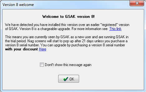
This version adds support for the Geocaching.com “Live” API (as hinted in yesterday’s release notes). This lets your macros access data direct from Groundspeak without packaging it in a Pocket Query first. There are more updates, but you can find all the nuts and bolts in the release notes.
Note this is not a free upgrade. Depending on when you purchased GSAK v7 (or v6) your upgrade price ranges from $25 to $5.
[ GSAK ] [ GSAK v8 Release Notes ]
Sep 27 2011
Here’s an interesting update that just came out for the Garmin Montana series. You can tweak the paperless geocaching now to be more OpenCaching like, or more “Traditional” (aka Geocaching.com) like, or combine them both.
This is handy for telling at a glance whether the cache is listed on Garmin’s OpenCaching.com site, or elsewhere. My immediate thought turns to noting which site I’m going to log the cache find on or potentially seeing cross listed caches for logging both quickly.
In “Traditional” View (seen above), the list hows Groundspeak icons, and the Difficulty/Terrain stars. The same information shows on the map view.
Switch the unit over to “OpenCaching” mode and that all changes. You’ll now see the icons shown in OpenCaching.com’s brown palette and the radar view showing the Difficulty, Terrain, Size and Awesomeness rankings.
Of course, you can see them combined in list view as well.
The Dashboards and Filters also reflect the changes. To see the Opencaching filter screen, you have to set your “Geocaching Style” to OpenCaching.com, or if you have only OpenCaching caches on your unit you can use “Auto”
While Garmin says the changes are only available on their giant flagship Montana handhelds, the blog post promises more units will support the feature soon.
[ via GPSTrackLog / Rich Owens ][ Garmin Paperless Opencaching ]
Aug 20 2011
Not to be outdone by Groundspeak’s “Challenges” updates, Garmin’s Opencaching.com site has also posted a site update. Most of the changes are little UI tweaks like making the map full screen, and updated searching.
There are some GPS specific changes though. If you have a Montana, 62 series, Oregon or Dakota, there’s a firmware update waiting for you. This will let you rate a cache’s “awesomeness” in the field, and participate in the new digital verification feature. Colorado owners (like me) are left out in the cold on this one.
Digital verification lets a cache owner verify your find by having you scan a QR code, enter a code manually or … respond to a chirp beacon. The manual code method will work for owners of older devices and I presume the QR code feature will make it’s way to the smartphone apps. Otherwise only those of you using an absolute top of the line camera built in Garmin GPS need apply.
Another tidbit that I found in the release is that the Garmin Dakota a week giveaway has expanded from the USA to include Canada now. Every 10 approved caches placed before August 28 earns you an entry to win a Dakota 20 GPS.
[ Garmin OpenCaching Update ] [ Garmin Advanced Geocache Logging ]
Aug 18 2011

It’s not Tuesday, but as expected Groundspeak has taken the site offline to launch Challenges ahead of Groundspeak’s big Block Party.
We’ve been over challenges already, the part I noted in the announcement was more the details about the fact that changes are already planned:
Challenges is a work in progress! We are planing several hotfixes in the next couple weeks to address bugs and feature requests. Some ideas for the next phases include:
- Highly rated Challenges displayed in geocache search results
- Pocket Queries for Challenges (and GPX downloads)
- Mapping tools
- New Challenge Types
- Support for verification questions
Also noteworthy in the update is some minor changes to logs and profile pages. They are working toward diminishing the find count from being visible on the cache logs – instead of showing Handle (5000 found) there’s a little bar chart underneath your profile thumbnail pic (that pic is new). You can hover your mouse on the thumbnail pic for more details on finds/challenge completions.
Challenges are a new feature to experiment with, and Groundspeak will be issuing a new challenge once a day to get things started up. Premium Members will also be able to post one per day, and we’re getting a “thumbs up/thumbs down” ranking for these challenges. (Now there’s quite a few people asking for that for caches, but we only got the “thumbs up” on that one). [ Groundspeak August 18th Release Notes ]
Aug 02 2011

Geocaching.com has gone down for it’s monthly maintenance window. But the Release Notes have a gem. This update activates the third party developers API. That means you can get things like smartphone apps, which use live data – and not have them resort to site scraping. This API has been a very controversial popular request, as seen on UserVoice

The first app out the gate is CacheSense, a Blackberry geocaching application. This fills a bit of a need since Groundspeak has not created an official Blackberry app. Well, there was that Trimble thing but really, this fills the niche better.
Also notable, you can now put 15 attributes on your cache page instead of 10. Might be time to revisit your listings and see if you need to add anything that didn’t make the cut before. There are also some new attributes – Seasonal Access, Teamwork Required, Tourist Friendly, Tree Climbing and Front Yard
The rest of the changes happening today follow:
What else is new?
New
• Added a video to Geocaching.com/iPhone showing the Geocaching for iPhone application in action • Added new cache attributes: Seasonal Access, Teamwork Required, Tourist Friendly, Tree Climbing and Front Yard (private residence) • Added Hungarian translations to Geocaching.com • Retroactively awarded Mega event Souvenirs for 4 recent events • Increased total number of assignable cache attributes from 10 to 15 • Localized Basic and Premium registration pages so they can be translated in other languages • Increased the number of Trackable activation codes that can be retrieved within a one hour period • Added an option in search results to highlight “beginner caches” (low difficulty/traditional type/recently found etc.) • Added Twitter and Facebook sharing options to cache log pages, visit your profile or geocaching.com/my/sharing.aspx to connect your accounts • Added the ability to temporarily close the yellow banner announcing scheduled maintenance on Geocaching.com • Updated Terms of Use Agreement (Section 4) to clarify age restriction for posting to Groundspeak Discussion Forums
• Added special Block Party icon for annual Groundspeak headquarters event
Bug Fixes
• Removed meta tags from cache page source of unpublished cache pages so spoilers are not revealed pre-publication • Fixed bug which caused a Trackable to enter a limbo state if marked missing and moved to the owner’s collection • Membership referral field when creating an account will now properly recognize extended characters in usernames • Changed “Waypoint Name” to “GC Code” on Create a Pocket Query form • When previewing a Cache Along a Route the highlighted portion of the map will now properly adjust in size based on the zoom level • Added Chatham Islands as a region for New Zealand and now allowing caches placed there to have a West longitude • Fixed bug on home page search where street addresses were not recognized without a postal code • Fixed bug which prevented marking a Trackable missing when language set to German or Czech • Added missing “generic” Geocoin icon to Trackables inventory page and Trackable map • Fixed bug where retracted caches would still appear on the map for a short time • Fixed support request form to properly auto-populate your username when filling out a support inquiry • Caches found in the African nation Congo no longer incorrectly appear on the statistics map in the Democratic Republic of the Congo • Fixed profile statistics display in which the first cache type in a bar chart was truncated • Fixed bug in advanced search which improperly included found or owned caches in search results when the user requested they be excluded • Disabled Send to GPS link for PMO caches when viewed by a logged in Basic Member • Fixed paragraph formatting for print-friendly cache pages • Added a new text entry field on Trackables lookup page for situations where the Trackable ID was first entered incorrectly • Fixed bug which prevented the resending of validation emails when the first email was misplaced • Updated cache creation page to require a state selection when submitting caches for Belgium • Fixed Trackables description display issue which cause emoticons to disrupt HTML formatting • Updated cache log smiley icons to the higher contrast versions used on the map • Fixed styling issue on account creation page causing error message to be misaligned • Changed link on Travel Bugs ordering info page from shop.groundspeak.com to shop.geocaching.com
• Added ability for cache owners to set the “Needs Maintenance” attribute on caches they own
[ Geocaching.com August 2 Release Notes] [ CacheSense ]
Jul 11 2011

The Ontario Trails Project has been updated to version 0.79. It’s not actually complete with all the trails I have but I felt it was time to release what I have for summer trip use. The big news is Algonquin portages and some other canoe routes, thanks to CANVEC data. I have a long way to go – Algonquin isn’t complete but there’s a pretty good amount of trails around Opeongo Lake and the west side of the park. I’ll be adding more canoe routes / portages as the summer continues.
If you’re out capturing trail data, make a note of interesting things along the trail too – I’ve added a couple new data sets, mainly informative bits like the cairn shown above but I’m also marking things like waterfalls and – for the canoeists – dams.
You can grab the map update at the usual spot, and here’s what’s new:
Ont-Trails 0.79
Added: New data type "Information". Shows interesting POIs along trails, or trail notes where applicable.
Added: New data type "Dam". Shows dams along canoe routes.

Added - New sections of Etobicoke Creek Trail near YYZ - Mississauga - northernpenguin
Added - Killarney PP - (some) Portages on George Lake, Killarney Lake, O.S.A. Lake - northernpenguin
Added - Tar Vats Trail - Killarney - northernpenguin
Added - New trail over QEW in Hamilton - Hamilton - John Carriere, dfx
Added - unnamed trail - Fonthill - dfx
Added - Welland Canal Trails (East side) - Port Weller - dfx
Added - Trestle Trail - Port McNichol - dfx
Added - Thiffault Nature Trail - Coldwater - dfx
Added - Optimist Park - Burlington - dfx
Added - Durham Region Forest Trails - Uxbridge - entogeek
Added - Walker Woods Trails - Uxbride - entogeek
Added - Sheaves Tower Trail - Blair - northernpenguin
Added - three trails from Nonquon Area - Nonquon - entogeek
Added - Long Sault CA Wild Turkey Trail - Clarington - entogeek
Added - Cowan Trail - Coldwater - entogeek
Added - Beausoleil Island (Georgian Bay Islands NP) - Georgian Bay Islands NP - Speedy54
Added - Side Trail in Hampton CA - Orono - Barnie's Band of Gold
Added - Portions of Sutton-Zephyr Rail Trail - Brown Hill - Speedy54, entogeek
Added - Cup and Saucer Trail - Manitoulin - Fizbot
Added - Wolf Den Trail (Misery Bay PP) - Evansville (Manitoulin) - Fizbot
Added - Lakeshore Trail portions (Misery Bay PP) - Evansville (Manitoulin) - Fizbot
Added - Saugeen River Canoe Route - Hanover to Southhampton - Fizbot, northernpenguin
Added - Chutes Provincial Park - Massey - Fizbot
Added - Saugeen River Trail - Walkerton - northernpenguin
Added - Old CPR Trail - Walkerton - northernpenguin
Added - Sydenham River Canoe Route - Owen Sound - northernpenguin

Added - Numerous Portages,Canoe Routes - Algonquin PP - (CANVEC)
        Partial List of Lakes Affected:
        Oxtongue River
        Smoke Lake
        Claude Lake
        Norman Lake
        Bena Lake
        Mikado Lake
        Small Lake
        Bluebell Lake
        Shawandasee Lake
        Greenwood Lake
        Gateway Creek
        Snow Lake
        Ragged Lake
        Little Coon Lake
        Big Porcupine Lake
        Dividing Lake
        McGarvey Lake
        Whatnot Lakes
        North Grace Lake
        Lemon Lake
        Lake Louisa
        Lawrence Lake
        Pardee Lake
        Rock Lake
        Minkey Lake
        Rockaway Lake
        Kimball Lake
        Cache Lake
        Source Lake
        Pincher Lake
        McCraney Lake
        Maggie Lake
        Minnow Lake
        Whitespruce Lake
        Dace Lake
        West Harry Lake
        Floss Lake
        Oak Lake
        Panther Lake
        Petawawa River
        Timberwolf Lake
        McIntosh Lake
        McIntosh Creek
        Falcon Lake
        Furrow Lake
        Potter Creek
        Kearney Lake
        Pond Lake
        Pog Lake
        Whitefish Lake
        Sunday Lake
        Sunday Creek
        Fork Lake
        Norway Lake
        Rose Lake
        Opeongo Lake
        Sproule Lake
        Pinetree Lake
        Happy Isle Lake
        Wright Lake
        Blackfox Lake
        Redfox Lake
        Hiram Lake
        Whitegull Lake

Updated - Tiffen Centre Trails - Barrie - northernpenguin
Updated - Tom East Side Trail (BT reroute) - Hockley Valley - dfx
Updated - Hydro Corridor Trail - Burlington - dfx, northernpenguin
Updated - Bruce County Rail Trail - Port Elgin - northernpenguin
Updated - Beaver River Canoe Route - Slabtown - northernpenguin
Updated - Nottawasaga River Canoe Route - northernpenguin
[ Ontario Trails Project ]
Jul 05 2011

Well, Groundspeak has updated the iPhone app again. But this update is significant – it’s the first one to use the new Geocaching API and it shows. The immediate benefit is that the app is a little quicker and there is a new “Advanced Search” screen that lets you filter like crazy. You can turn on / off certain cache types, set a range for difficulty or terrain, pick certain sizes and … drumroll here …. you can filter caches that up to four of your geocaching friends have already found. How’s that for curing those “which cache is next?” arguments at the car!
Some teaser screen shots:

The GC app will update it’s database the first time you run it. Signs of big changes

… and you’ll have to re-authenticate due to the API

New Authentication Dialog

The API authentication is similar to apps like Twitter and Facebook now. See that “Allow Access” button?

Advanced Search Screen

Hidden at the bottom of the Advanced Search screen, you can filter out caches four of your friends have already found.
Head on over to the app store to get the update (or buy it).
From Groundspeak’s release notes:
Updates include:
- New Advanced Search to filter by location, cache type, difficulty/terrain, keyword, exclude your finds, exclude finds for up to 4 friends, and Premium caches
- Sync Personal Cache Notes between the website and your iPhone
- Create multiple offline cache lists to plan outings; useful when you may be travelling outside network coverage
- Download Pocket Queries to the iPhone to view cache details, images, and map tiles offline
- Numerous bug fixes to address performance and reliability
[ Geocaching App for iPhone ] [ Release Notes ]
May 03 2011

Geocaching.com is gearing up for a site update tomorrow. The site will be getting a new look and feel, with lots of changes visible on the main screen. There is a video posted on Latitude47, Groundspeak’s official blog, that shows what to expect.
From the Geocaching Forums, some lackeys are giving some small details about the planned outage:
Colin said:
Geocaching.com will be going offline for 4-6 hours for a site update on Wednesday, May 04, 2011 at approximately 9am PDT (GMT -7). We apologize for any inconvenience this may cause.
In an effort to keep people informed, here are some more details about the planned outage:
Estimated start time is 9 AM PST
Will be down:
- Geocaching.com
- Waymarking.com
- Wherigo.com
- Internal Groundspeak Admin tools
- User Voice: unless you are already logged in – User Voice itself will be up, but you won’t be able to login with Geocaching.com
- All API
- Notifications
- Pocket Queries
Will be up:
- Knowledge Books
- Forums will be operational
And, MissJenn added more detail about the involvement of the hamsters in the process (this was also in the weekly mailer):
… You may or may not be aware that Groundspeak’s servers are powered by hamsters.* We are adding several additional hamsters to the mix**, which should fix website service issues. Groundspeak products will go offline around 9 am Pacific Daylight Time (UTC/GMT -7 hours). We are not sure how long it will take to complete the upgrade; we estimate 4 to 6 hours, but it may be more or less. We will be providing updates on the 4th via Facebook and Twitter. When the Groundspeak products come back online, Geocaching.com will have an updated look and thewebsite performance will be improved.
*Our servers are not powered by hamsters
**Upgrading our database server
The short message here, is if you’re planning on geocaching tomorrow – generate and download your pocket queries now. The site will be out from noon to about 6pm Toronto time. You won’t be able to use the iPhone or Android apps either, unless you download a Pocket Query to your device and log with Field Notes instead of logs.
Mar 16 2011

Dale Atkin (Ibycus) has posted on the Groundspeak Forums, indicating that the newest release of his free (Garmin) topo map project for Canada is now ready. The new release features improvements for road features, particularly in Quebec and a newer version of the underlying topo data.
Just a quick note here to say that I’ve *finally* finished work on version 4.0 of the maps.
This version includes new roads for much of the country (including Quebec, which hadn’t been updated since the maps came up), as well as more areas with road names.
Also there is a new version of the underlying dataset for the topo data.
Finally included are what I *hope* are all of the more minor roads that disappeared between version 2.1 and 3.0. These are included as a transparent overlay that can be added to the maps (or any map for that matter).
I hope to get the torrent of the PC version going tonight.
Just a reminder, we have a Pro Tip posted for installing version 3 on our site. Version 4 should follow the same instructions.
You can obtain the map data using BitTorrent, here’s the tracker file. If you’re security minded, the MD5 SUM is also available for the Torrent:
MD5 Sum – 3ddd5edfaf793f9cadc6f449ec6d55e4 *IbycusTopo40.iso
[ Ibycus Topo 4.0 (BitTorrent) ] [ Ibycus Topo Home ]