TAG :: Toronto Area Geocachers » garmin
Jan 15 2011
 This tip is for the Colorado, Oregon, GPSMAP 62/78 and Dakota line of Garmin GPS recievers.
The story goes something like this. You upgraded your Garmin GPS receiver to the latest beta firmware. Perhaps it was because of a new feature, or a bug that was listed as fixed, or a bug that wasn’t listed but you were hoping was fixed, or you’re just a glutton for punishment. Whatever the reason, you’re now running the latest and greatest. Or so you thought… You notice that a new bug, or two, has been introduced. It’s serious enough that the reason you upgraded isn’t worth the aggravation. You want to go back.
If you were running a previous beta it’s easy. Just run the EXE file for that firmware and you’re back to where you were.
But what if you want to go back to a release version. You don’t have an EXE for that since you’ve probably used Webupdater to load it. No problem. Webupdater puts the firmware file in the Garmin folder on your unit in a file called gupdate.gcd. All you had to do was copy this file somewhere else before you rebooted your GPS receiver. Just copy that file back to the Garmin folder and reboot. You’re done.
“But I didn’t back up anything!”, you say. Since this is the first time you want to go back you probably didn’t make a back up of the firmware file. Fortunately you’re not stuck. The good folks at gpsfix.net have prepared for this possibility and have links to the firmware files on their wiki pages. Just download GCD file for the firmware you want, rename it to gupdate.gcd, put it in your Garmin folder on your GPS receiver and reboot.
There is one small gotcha. Going back to a previous version of firmware will reset all the settings on your GPSr. Your battery type, WAAS enabled, units, and other customizations will all go back to defaults. Your loaded maps, geocaches and custom POI will be left alone. Waypoints will probably survive as well.
Here’s the links to the wiki pages for all the GPS recievers:
- Colorado
- Oregon
- Oregon x50
- GPSMAP 62/78
- Dakota
Jan 13 2011
![]() Here’s a developing story from the Groundspeak Forums. It seems that the Federal Communications Commission in the United States are going to allow a radio licencing change that could potentially affect the GPS L1 signal quality – the frequency used by civilian GPS units. In the efforts to increase mobile broadband internet capabilities, the proposal is to allow use of a frequency that is adjacent to the frequency used by L1. This could potentially result in signal interference, particularly in or near urban areas.
Here’s a developing story from the Groundspeak Forums. It seems that the Federal Communications Commission in the United States are going to allow a radio licencing change that could potentially affect the GPS L1 signal quality – the frequency used by civilian GPS units. In the efforts to increase mobile broadband internet capabilities, the proposal is to allow use of a frequency that is adjacent to the frequency used by L1. This could potentially result in signal interference, particularly in or near urban areas.
According to the discussion thread, the FCC is planning to skip on the lengthy consultation process and fast track this in next week. Will they? We don’t know. We do know that Garmin is rather concerned about LightSquared’s proposal (see the first post in the forum thread). Americans are being encouraged to file a complaint.
How will this affect a Toronto geocacher? Can’t really say for now. The FCC regulates radio frequency use in the United States, while in Canada this is handled by Industry Canada. Interference from terrestrial mobile broadband is unlikely to affect GPS users in Canada, except perhaps near border cities like Niagara Falls.
Jan 07 2011
Starting with Colorado Firmware 3.52 beta, the device can listen for Garmin chirp devices. I loaded up that firmware and found very quickly it isn’t entirely intuitive to figure this out – it’s certainly not in the Garmin Colorado manual, having been added several years after the product line launched.
To use the feature, you have to enable it. As listening for chirp devices can potentially eat more battery on an already power hungry device like the Colorado, it is disabled by default. To enable it, go to your Geocaching menu, then select Options (top left button) and finally Start chirp(tm) searching.

When you encounter a chirp device, it will pop up automatically and grab the information from the chirp. Since the ANT hardware is not as efficient as it is in the newer Garmin devices you will have to be closer to the chirp. Once the chirp has finished communicating, you’ll have the option to display it’s details, or dismiss it.

To go back and see the chirp again after dismissing it, simply go back to Geocaches, then Options and select chirp(tm) Details.

To disable chirp, it’s the same procedure. Go back to Geocaches, then Options and select Stop chirp(tm) Searching.

The chirp details will be remembered until you encounter another chirp, you reboot the device or you disable chirp searching. That’s right, shutting off the device or disabling chirp erases the chirp details from the unit.
You’ll want to save any waypoint details you want to keep before shutting off. I have not found a way to save the information on the device itself, I’ll update this article if I find a way (there HAS to be a way).
Jan 04 2011
 If you’ve loaded up that 3.52 Colorado update, also run Webupdater as Garmin quietly posted a GPS Firmware update. At this point, we have no idea what changed. The GPS Software version stayed at 2.90 on my unit.
Jan 04 2011

Garmin has released a firmware update for the Colorado. What’s exciting is that they added Chirp support. There were mixed messages coming from Garmin tech support as to whether or not the Colorado’s hardware was capable of talking to a Chirp.

Colorado v3.52: Download
- Added support for chirp™ detection. This software update will allow Colorado units to detect previously-programmed chirp™ units. See http://www.garmin.com/chirp for details on which units are chirp™ compatible. NOTE: Due to the hardware present in Colorado devices, chirp™ detection range may be less than that of other compatible devices.
- Updated magnetic Earth field data.
- Fixed issue with certain JPEGs not drawing from Custom Maps.
- Fixed issue with Oblique Mercator User Grid distances.
Jan 04 2011

Today, Garmin has set another milestone by releasing a Navigation app for iOS devices (iPhone, iPad).
The application is a full 2D or 3D automotive navigation application, based on the popular StreetPilot series GPS units. It supports the usual functions including POI databases, routing to your contacts on your iPhone or even calling them, and of course, traffic (and even weather). Voice prompting with street names is included and it will operate in Portrait or Landscape modes.
This uses City Navigator NT data, and pulls it “over the air”, from Garmin servers. This is similar to Mapquest 4 Mobile. The advantage is you will not be sucking up a Gigabyte of space on your device for local maps like Navigon’s 1.6GB for example. The disadvantage is that you will consume 3G data while using the application. Traffic is also included (it’s $10/year on Navigon)
It is available only in the United States (UPDATE: USA and Canada) right now (so not available to us Canadians just yet, but the USA version has Canadian Maps). Cost is comparable to competing products, at $39.99 USD.
What makes this important is that it is the first real effort to supporting iOS device users, and likely a sign of things to come.
UPDATE: It’s showing up in the Canadian iTunes store too now, for $39.99 CAD
Jan 03 2011
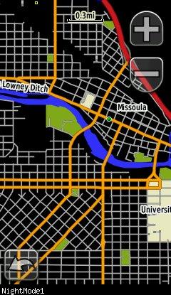
Night Colour on an Oregon (from GPS File Depot)
Found this little gem on the Groundspeak Forums.
One of the complaints that many owners of the newer Colorado and Oregon GPS units have is the lack of a “night mode” that other Garmin GPS units have. Night mode on a Nuvi or 60 series GPS for example will, at sunset switch from a light background to a dark background. This reduces the glare and distration from that dashboard mounted GPS.
Many geocachers bought their Colorado/Oregon/Dakota units as you could load City Navigator NT on the unit and use it as both an outdoor GPS for hiking AND as a navigation device. The Colorado even ships with an “automotive” profile for this purpose. For unknown reasons, Garmin left the day/night mode function out of the Colorado and it’s kin.
Fortunately, yogazoo has created a hack in the form of a map overlay that will deliver the same effect. He has produced a transparent map that, when activated will darken the screen for City Navigator maps in the USA and Southern 2/3 of Canada. You will have to switch the map manually. Still, this is a welcome relief for those of us who drive a lot after dusk yet don’t want the distraction of a bright, light coloured map display.
You can find it at GPS File Depot
Dec 22 2010
Garmin has release a second round of firmware updates for their Geocaching capable receivers.
GPSMAP 62/78 v2.92: Download
- Fixed issues with WAAS/EGNOS
- Fixed issue with progress bar displaying properly on power up
- Fixed issue with track navigation not adding waypoints to the Active Route list when they are exactly equal to a track point
Oregon v4.12: Download
- Fixed issues with WAAS/EGNOS
- Fixed issue with photo viewer not displaying correctly
- Fixed issue with 3D view
- Fixed issue with track navigation not adding waypoints to the Active Route list when they are exactly equal to a track point
Oregon x50 v4.32: Download
- Fixed issues with WAAS/EGNOS
- Fixed issue with moon not showing on sun and moon page
- Fixed issue with photo viewer not displaying correctly
- Fixed issue with progress bar displaying properly on power up
- Fixed issue with waypoint distances showing significantly off in the waypoint manager
- Fixed issue with 3D view
- Fixed issue with track navigation not adding waypoints to the Active Route list when they are exactly equal to a track point
Dakota v3.82: Download
- Fixed issues with WAAS/EGNOS
- Fixed a hang that occurred when a unit had 1000 auto-named waypoints
- Fixed issue with track navigation not adding waypoints to the Active Route list when they are exactly equal to a track point
As always, use at your own risk. If you have to go back to a previous version of firmware it will reset all your settings to default.
Dakota software version 3.82
Dec 18 2010
Garmin has also released beta firmware for the Oregon series. Very similar list of fixes:
- Updated magnetic Earth field data
- Improved GPS performance
- Fixed issue with track navigation sometimes not adding waypoints to the Active Route list
- Fixed issue with MPC map labels disappearing
- Fixed shutdown on the map page when you have a geocache dashboard active and return after pressing the geocache name
The firmware can be downloaded either here Oregon Updates & Downloads or here Oregon x50 Updates & Downloads depending on which model you own.
The Dakota also has beta firmware, again with a very similar list of fixes:
- Updated magnetic Earth field data
- Improved GPS performance
- Fixed issue with track navigation sometimes not adding waypoints to the Active Route list
- Fixed issue with MPC map labels disappearing
The firmware can be downloaded here: Dakota Updates & Downloads
Dec 18 2010
 Garmin has made the beta v2.91 firmware for the GPSMAP 62/78 series GPS receivers available for download. As with all beta firmware, use at your own risk.
The fixes in this version:
- Updated magnetic Earth field data
- Improved GPS performance
- Fixed issue with track navigation sometimes not adding waypoints to the Active Route list
- Fixed issue with track and route review from the map page if you came from the elevation plot
- Fixed issue with MPC map labels disappearing
- Fixed issue with gpi files that have alerts attached to the points
The firmware can be downloaded at: GPSMAP 62/72 Updates & Downloads